Later today I'll post an update of the conditions expected for this week. No change on the forecast, COLDEST WEEK IN YEARS. EXPECT LOWS IN THE -5°C TO -4°C RANGE FOR THE CITY AND UP TO -10°C FOR THE RURAL AREAS.
MORE ON THIS LATER.
Cheers.
Monday, January 31, 2011
Thursday, January 27, 2011
COLD, COLD, COLD, COLD, COLD BR$#%&"!
I think the title might be self-explanatory as of now. But first:
LOCAL/REGIONAL FORECAST
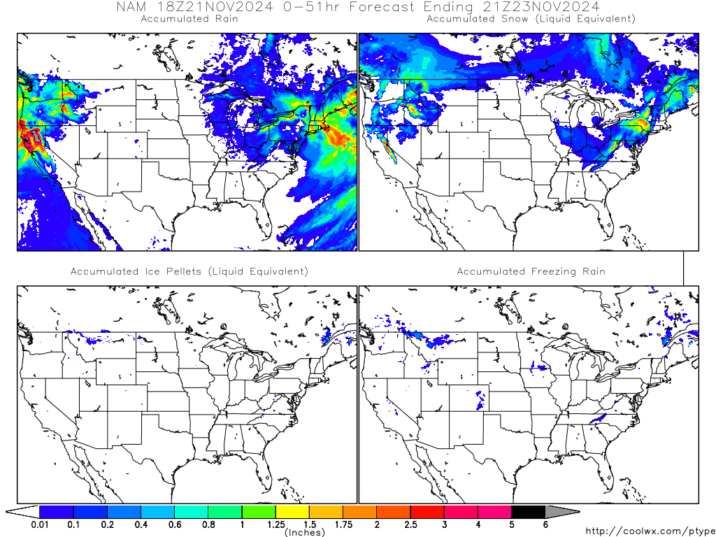
This week it's moving around normal, with a trend to slightly cooler conditions for today, tomorrow and Saturday. Moisture from the gulf could enhance some orographic precipitation for Thursday and some scattered showers by Saturday, yet rain amounts should generally be less than 1/4 of an inch. Nuevo León, Coahuila and Tamaulipas should expect good conditions until Monday, with temperatures moving from the 40s and 50s early in the morning reaching 70s and 80s by the afternoon. Partially cloudy skies should predominate the next 4 days.

LOCAL/REGIONAL FORECAST
This week it's moving around normal, with a trend to slightly cooler conditions for today, tomorrow and Saturday. Moisture from the gulf could enhance some orographic precipitation for Thursday and some scattered showers by Saturday, yet rain amounts should generally be less than 1/4 of an inch. Nuevo León, Coahuila and Tamaulipas should expect good conditions until Monday, with temperatures moving from the 40s and 50s early in the morning reaching 70s and 80s by the afternoon. Partially cloudy skies should predominate the next 4 days.
NATIONAL FORECAST
 |
| ACAPULCO |
 | |
| MONTERREY |
 |
| CANCÚN |
 |
| MEXICO CITY |
UPDATE POTENTIAL SEVERE COLD OUTBREAK

Since last week, computer models started trending to a serious cold period during the first week of February for Southern Texas and the entire NE Mexico. The GFS showed the cold and then fold back, while the Canadian, the European and the JMA show now consistently a severe period of cold weather through the first 7 days of February with temperatures plummeting below zero for Monterrey and most parts of the region with the potential of a snow/ice threat for even as south as Lower Rio Grande Valley.
Now, quoting JB:
" Well, we got a huge disruptive problem coming
next week, and with it, the threat of ice deep into the heart of Texas
(I could see it getting to I-10 in western Texas for instance, and a
freeze to the lower RGV which is almost unheard of (I think it is, but
I haven't looked at everything yet) to the lower Rio Grande Valley."
Now what do the models look like?
GFS = Shows a snow storm developing over northern Texas, moving NE. Still underestimating cold and moving the air mass too far east.
ECMWF = Shows temperatures below freezing falling below -5°C for 2 days, enough moisture that might trigger some snow showers with some wintry mix. Really cold week in general.
CANADIAN= Just take a look:
So pretty much, next week highlight will be the severe cold event throughout the region and what surprises it might show us down here! Just to give you an insight of how cold it might get, the european shows the 540mb SOUTH of Monterrey for around 24 hours. THAT IS FREAKING COLD!!
Cheers.
Sunday, January 23, 2011
Calm and cool conditions expected throughout the week, but... COLD might be back in 10 days.
LOCAL FORECAST/REGIONAL FORECAST
Beautiful day around Monterrey today with temperatures expected to reach 24°C and with clear skies. Calm weather is common around the city and in general over NE Mexico, a cold front will be arriving later tonight and a stronger one on tuesday making temperatures drop into the 5-8°C range as for lows having as highs 15-20°C throughout the week. Some moisture might be popping into the region by tuesday, so some scattered showers are plausible. This January has been running below normal, specially due to last week extreme cold that created ice and sleet conditions for most parts of the region above 4000 feet.
MID-LONG RANGE SPECIAL ANALYSIS
Since the last 4 days, the GFS has been consistently calling for a brutal period of cold weather throughout Monterrey and NE Mexico for the first week of February. The GFS is even calling for upto 10-18 OUTSTANDING INCHES OF SNOW!!!!!! Even though, the GFS is known for its wild contrast from one run to another, it has been really consistent in showing a period of extraordinary cold weather for the first week of February with temperatures running below zero for several days. Check out some of the runs of the GFS:
EVEN THOUGH THE FORECAST IS BEYOND 200 HOURS FROM NOW, THE CONSISTENCY OF THE LAST 3-4 DAYS MIGHT BE CLAIMING THAT SOMETHING SERIOUS IS GOING TO HAPPEN IN A MATTER OF DAYS. MORE ON IT LATER THROUGHOUT THE WEEK.
INTERNATIONAL UPDATE
**FREAKING COLD OVER NE US**
Temperatures are remarkably cold for the entire Northeastern United States. Expect temperatures to plummet below zero from Central Pennsylvania, Central New York and Northward tonight. RealFeel temperatures could get bitterly cold over the region with readings of upto -40°F!!!! A potentially dangerous storm is expected to arrive by tuesday-wednesday. Expect the heaviest snow to be due west of the big cities. Some mixture will be likely at coast with most of it rain, creating hazardous conditions by mid week. Precautions should be taken with a really rough weather coming ahead. For more: BONECHILLING-DANGEROUS-COLD - ACCUWEATHER.COM
**NO EXTREME COLD INSIGHT FOR THE UK/IRELAND**
After being a remarkable 7.5 Below normal for December, January is running at 2.2 above. JB claims that it doesn't mean a day or two of cold or snow can't show up. The core of the cold for the rest of the winter in Europe will now run for the south region and to the southeast of UK and Ireland. For more, look at Accuweather.com and http://markvoganweather.blogspot.com/ .
**DRY WEATHER FOR THE SUB-CONTINENT**
Cheers.
Beautiful day around Monterrey today with temperatures expected to reach 24°C and with clear skies. Calm weather is common around the city and in general over NE Mexico, a cold front will be arriving later tonight and a stronger one on tuesday making temperatures drop into the 5-8°C range as for lows having as highs 15-20°C throughout the week. Some moisture might be popping into the region by tuesday, so some scattered showers are plausible. This January has been running below normal, specially due to last week extreme cold that created ice and sleet conditions for most parts of the region above 4000 feet.
 | |||
| Courtesy of Accuweather.com |
Since the last 4 days, the GFS has been consistently calling for a brutal period of cold weather throughout Monterrey and NE Mexico for the first week of February. The GFS is even calling for upto 10-18 OUTSTANDING INCHES OF SNOW!!!!!! Even though, the GFS is known for its wild contrast from one run to another, it has been really consistent in showing a period of extraordinary cold weather for the first week of February with temperatures running below zero for several days. Check out some of the runs of the GFS:
 |
| CHECK OUT THAT MASS OF ARCTIC AIR MOVING SOUTHWARD FROM NORTHERN US (AN ASTONISHING -26°C BELOW NORMAL) LOOP: GFS TEMPERATURE ANOMALIES |
 | |
| CHECK OUT THE 0°C LINE AND THE AMOUNT OF QPF, ALMOST .5 INCHES OF LIQUID!!!! AND PREVIOUS HOURS SHOW EVEN MORE! |
 |
| OVER HALF AN INCH OF PRECIPITATION AND TEMPS BELOW ZERO!!!! |
INTERNATIONAL UPDATE
**FREAKING COLD OVER NE US**
Temperatures are remarkably cold for the entire Northeastern United States. Expect temperatures to plummet below zero from Central Pennsylvania, Central New York and Northward tonight. RealFeel temperatures could get bitterly cold over the region with readings of upto -40°F!!!! A potentially dangerous storm is expected to arrive by tuesday-wednesday. Expect the heaviest snow to be due west of the big cities. Some mixture will be likely at coast with most of it rain, creating hazardous conditions by mid week. Precautions should be taken with a really rough weather coming ahead. For more: BONECHILLING-DANGEROUS-COLD - ACCUWEATHER.COM
 |
| Courtesy of Accuweather.com |
**NO EXTREME COLD INSIGHT FOR THE UK/IRELAND**
After being a remarkable 7.5 Below normal for December, January is running at 2.2 above. JB claims that it doesn't mean a day or two of cold or snow can't show up. The core of the cold for the rest of the winter in Europe will now run for the south region and to the southeast of UK and Ireland. For more, look at Accuweather.com and http://markvoganweather.blogspot.com/ .
**DRY WEATHER FOR THE SUB-CONTINENT**
The entire Sub-Continent will have an absolute dry weather spell from 23rd. till the 27th.
No
W.D. in the Northern regions, and the Easterly wave may initially
precipitate rains in Sri Lanka, and maybe the South T.N. coast, but
after the 28th. - Rajesh Kapadia
For more: Vagaries of the weather
Cheers.
Thursday, January 20, 2011
Wednesday, January 19, 2011

Monday, January 17, 2011
Tranquil weather ahead...for now
LOCAL UPDATE
After an extremely cold week with temperature departures averaging -24°F throughout the city, finally the sun came out on Sunday and tranquil weather rules the region as of now. Even though temperatures at the morning remain at a chilly 8-10°C, afternoons are milder with highs around 25°C. However cold and dampness looms next weekend. A powerful cold front moving southward from Northern Canada will bring down the temps again yet it is to see if it will challenge last week's cold.

Expect nice conditions, partially sunny skies with chilly nights and milder afternoons throughout the region until Friday when the cold front will arrive. Temps should be around 5°C and no higher than 12°C during the last days of this week. Also rain and drizzle are likely for those days. Throughout the region expect cold conditions in the latter part of this week with lows ranging near freezing for most of Coahuila and high terrains of Nuevo León, while milder conditions will be present at southern Tamaulipas.
**MIGHTY COLD WEATHER FOR THE LATTER PART OF THE WEEK FOR THE MIDWEST**
SUBZERO DAYS ARE POSSIBLE FOR MINNEAPOLIS AND EVEN CHICAGO WITH THIS ARCTIC AIR MASS STREAMING SOUTHWARD FROM THE POLE. A LATE WEEK STORM SEEMS QUITE PLAUSIBLE FOR THE NORTHEASTERN US YET IT MIGHT BE A REALLY MESSY ONE WITH LOTS OF MIXTURE INVOLVED DIRECTLY AT THE COAST.
FOR MORE:
Cold Will Hold in East and Plains through Mid-February - ACCUWEATHER.COM
Ice Storm Aims For Populated Areas - ACCUWEATHER.COM
*UPDATED WINTER FORECAST BY ACCUWEATHER.COM*
LONG STORY SHORT:

FOR MORE:
Year of Extremes Strongest La Niña: What it Means for Upcoming Months
*UK WEATHER AND INTERNATIONAL WEATHER:*
SEVERE COLD BUILDING OVER NORTH-CENTRAL CANADA, SET TO PILE DRIVE SOUTH INTO HEART OF USA THIS WEEK! - Weather & Climate Through the Eyes of Mark Vogan
*INDIA WEATHER:*
Latest Feedback on snowfall in Nepal received from Neeraj - Vagaries of the Weather by Rajesh Kapadia
Cheers.
After an extremely cold week with temperature departures averaging -24°F throughout the city, finally the sun came out on Sunday and tranquil weather rules the region as of now. Even though temperatures at the morning remain at a chilly 8-10°C, afternoons are milder with highs around 25°C. However cold and dampness looms next weekend. A powerful cold front moving southward from Northern Canada will bring down the temps again yet it is to see if it will challenge last week's cold.

WHAT TO EXPECT?
Expect nice conditions, partially sunny skies with chilly nights and milder afternoons throughout the region until Friday when the cold front will arrive. Temps should be around 5°C and no higher than 12°C during the last days of this week. Also rain and drizzle are likely for those days. Throughout the region expect cold conditions in the latter part of this week with lows ranging near freezing for most of Coahuila and high terrains of Nuevo León, while milder conditions will be present at southern Tamaulipas.
INTERNATIONAL UPDATE:
**MIGHTY COLD WEATHER FOR THE LATTER PART OF THE WEEK FOR THE MIDWEST**
SUBZERO DAYS ARE POSSIBLE FOR MINNEAPOLIS AND EVEN CHICAGO WITH THIS ARCTIC AIR MASS STREAMING SOUTHWARD FROM THE POLE. A LATE WEEK STORM SEEMS QUITE PLAUSIBLE FOR THE NORTHEASTERN US YET IT MIGHT BE A REALLY MESSY ONE WITH LOTS OF MIXTURE INVOLVED DIRECTLY AT THE COAST.
FOR MORE:
Cold Will Hold in East and Plains through Mid-February - ACCUWEATHER.COM
Ice Storm Aims For Populated Areas - ACCUWEATHER.COM
*UPDATED WINTER FORECAST BY ACCUWEATHER.COM*
LONG STORY SHORT:
FOR MORE:
Year of Extremes Strongest La Niña: What it Means for Upcoming Months
*UK WEATHER AND INTERNATIONAL WEATHER:*
SEVERE COLD BUILDING OVER NORTH-CENTRAL CANADA, SET TO PILE DRIVE SOUTH INTO HEART OF USA THIS WEEK! - Weather & Climate Through the Eyes of Mark Vogan
*INDIA WEATHER:*
Latest Feedback on snowfall in Nepal received from Neeraj - Vagaries of the Weather by Rajesh Kapadia
Cheers.
Friday, January 14, 2011
Accuweather's story on the recent cold wave at Northeast Mexico
From ACCUWEATHER.COM
Special thanks to Jesse Ferrell for the story
Rare Cold Wave, Ice in Northeast Mexico
Jan 14, 2011; 3:21 PM ET
A rare cold snap has chilled northeast Mexico this week, leading to school truancy, opened shelters for residents, and rare freezing rain in some places. AccuWeather.com Facebook Fan Arturo S., who has reported on weather stories there previously, said:"Look how much ice accumulated at Chipinque Park, which is above 4000 ft and less than 8 mi from downtown Monterrey. Local rangers claim old trees fell due to the weight of the ice, something really uncommon. Ice started around Tuesday night and lasted until yesterday by noon."This YouTube video shows a view of the ice:
NOTE: All references to news stories below are in Spanish but you can translate them via Google, which is where the translations I use come from.
The freezing rain was confirmed by a local newspaper which said "In the metropolitan area, the low temperatures ranged between one and three degrees accompanied by a persistent drizzle that led to a marked truancy in the schools." Another article claims that 90% of students from one state were missing from their classrooms on Tuesday.

Weather records are hard to come by south of the border, but our weather database said that Saltillo's temperatures on Tuesday featured a low of 25 F and a high of 34 F -- their normals this time of year are 48 & 68! That took them to an incredible -24 F for an average departure. With a high temperature of 42, Monterrey's departure from average was -19 F. A map of the coldest temperatures this month is shown above.
It wasn't just cold -- but also wind and waves near Oaxaca - a media report said "occasional gusts to 110 kilometers per hour on the Isthmus and Gulf of Tehuantepec, gradually weakening and waves up to four meters high in the coastal zone." In Victoria, the cold wave was blamed for a 30% increase in respiratory diseases. And near Saltillo, a 30-car pileup was caused by fog, and I imagine ice might have had something to do with it.
AccuWeather.com - WeatherMatrix | Rare Cold Wave, Ice in Northeast Mexico
Brief update
Thanks to Jesse Ferrell for the blog in which my reports appeared!!!!!
AccuWeather.com - WeatherMatrix | Rare Cold Wave, Ice in Northeast Mexico
Cheers.
Thanks to Jesse Ferrell for the blog in which my reports appeared!!!!!
AccuWeather.com - WeatherMatrix | Rare Cold Wave, Ice in Northeast Mexico
Cheers.


INTERNATIONAL LATEST
Rio struggles with the aftermath of deathly floods - CNN.com
flooding mudslides kill scores near Rio de Janeiro - france24.com
Weekend of Jan. 22-23 May be Brutally Cold for the US - Accuweather.com
Weather and Climate Through the Eyes of Mark Vogan
http://rajesh26.blogspot.com/
Cheers.
Wednesday, January 12, 2011
ICE AT THE MOUNTAINS!
**CHILL**
ICE TODAY IN THE MORNING AT CHIPINQUE PARK IN THE SIERRA MADRE RANGE, LOCATED AROUND 4000 FEET ABOVE SEA LEVEL. TEMPERATURES WERE AROUND 29°F.


 |
| SOURCE: ELNORTE.COM |
COLD AND DAMP DAYS AHEAD
TODAY'S HIGHLIGHTS
Current conditions at the Metropolitan area of Monterrey are really chilly and damp with realfeel temps below freezing and temperatures fluctuating between 35-38°F. At the previous post you can observe some freezing rain and icing at the Sierra de Santiago which is located 15 miles southwest of the city and around 6,000 feet above sea level. Steady drizzle all day long has fallen and continues to fall. Already some sleet and snow reports have appeared at the mountainous range at Central Coahuila (around 300 km due northeast of the city).
WHAT TO EXPECT?
NAM keeps calling for some freezing rain and even some snow for suburban areas around the city and the mountains. Expect near or sub-freezing temps at late evening and throughout the night.
Tommorrow stays again chilly and damp with temps oscillating between low 30s and low 40s. Throughout the region expect freezes and hard freezes for Coahuila, Nuevo Leon and the Tamaulipas Valley near Lower Rio Grande Valley. Friday remains damp too, however a slight recovery at temps is expected with lows in the 40s and highs struggling to reach high 50s across the region. Rain conditions might continue throughout the weekend but expected a noticeable recovery by sunday once the moisture from the gulf and a developing storm in the northern Gulf of Mexico passes by.
INTERNATIONAL LATEST
**NEW ENGLAND HIT BY A BLIZZARD **
MORE THAN 2 FEET OF SNOW WERE REPORTED AT NEW HAVEN AND THE CONNECTICUT AREA, NEARING 30 IN. IN SOME LOCAL SPOTS. THE SWEET SPOT THAT I MENTION DAYS AGO OF WERE THE REAL JUICE OF THIS STORM WOULD BE SEEMS TO FIT PROPERLY TO REALITY.
SOME REPORTS GO AS FOLLOWS FROM NOAA AT CONNECTICUT

RADAR LOOP AT NE STORM

FOLLOW THIS GREAT VID FROM STORMTOPIA.COM
FOR MORE KEEP AN EYE ON THE NORTHEAST QUADRANT
**AUSTRALIAN CATASTROPHIC FLOOD**
THE AUSTRALIAN CATASTROPHIC FLOOD AT QUEENSLAND KEEPS ON AND EXTREME DAMAGE HAS BEEN MADE TO AUSTRALIA'S THIRD LARGEST CITY BRISBANE. NEAR RECORD FLOOD STAGE CONDITIONS WERE REPORTED AS SAME AS HEAVY DAMAGE TO THOUSANDS OF STREETS, BUSINESS AND INFRAESTRUCTURE. THE STATE PREMIER CLAIMS THIS FLOOD TO BE GREATER THAN THE 1974 FLOOD AND CALLED THIS AS A "100 YEAR EVENT". RELIEF MIGHT BE INSIGHT BUT WILL COME WITH A SLOW PACE AS SOME SCATTERED SHOWERS WILL CONTINUE THROUGHOUT THE REGION DURING THE REST OF THE WEEK.
FOR MORE READ THE ARTICLE AT:
NEXT UPDATE LATER IN THE EVENING OR TOMORROW. DEPENDING ON WEATHER EVENTS.
Cheers.
Tuesday, January 11, 2011
WHAT A CHANGE!!
CHECK OUT THIS TEMPERATURE DEPARTURES!!!

READINGS GO OFF SCALE!!!!!!! CURRENTLY AT 43°F and lots of light rain and drizzle.
NO SURPRISE IF THROUGHT TONIGHT, WEDNESDAY AND THURSDAY MONTERREY GETS SOME WINTRY SURPRISES!!! TOO MUCH HUMIDITY AND COLD AIR POURING SOUTHWARD. MOUNTAINS WILL GET HARD HIT WITH FREEZES, SLEET AND ICING.
NE STORM UPDATE:
**NE QUADRANT UPDATE**
FOR MORE INFO AND EXCELLENT ANALYSIS CLICK HERE: NE QUADRANT
UPDATED SNOWFALL FORECAST as of 4:30 p.m., Tues. 1-11-11: Snowfall totals have been lowered slightly across the south and western portions of the NYC metro region, and heaviest snows have shifted a bit east. Every section has a "+" because snowfall varies significantly where banding sets up. Green = 12-18"+ / Red = 8-1 ...2"+ / Purple = 5-8"+ / Blue = 3-6"+ / Yellow = 2-4"+ / Orange = 1-3"+...

SOON ANOTHER UPDATE.
Cheers.
Monday, January 10, 2011
POST YOUR EXPERIENCE, SHARE IT WITH THE WORLD!
FEEL FREE TO POST YOUR SNOW TOTALS, IMAGES AND THOUGHTS FOR THIS UPCOMING SNOW EVENT FOR THE EAST COAST:
UPDATE FROM THE NORTHEAST QUADRANT:
UPDATE FROM THE NORTHEAST QUADRANT:
NEQ’s updated forecast, as of 3:30 pm, Mon. 1-10-11: Washington DC metro: 1-3” / Baltimore metro: 2-4” / Baltimore to Philly: 3-6” / Philly metro: 6-9” / Philly to New York: 6-12” / immediate New York City metro, including Long Island: 10”+ / New York City to Boston: 10-15”+ / Boston metro: 15”+
FIND OUT MORE LIVE FEED AND GREAT INFO FROM:
THE NORTHEAST QUADRANT
**UPDATE FROM JB**:
Look out New England , south and east and Long Island. NYC a big storm by any other year, but not as big as the blizzard. ( I like 12 there for an average)
 |
| Courtesy of Devin Toporek during the Great Blizzard of DEC 2010 at NYC |
Cheers.
Big Snowstorm for NE!!!!
Big Snowstorm for NE!!!!
Meteorologist Henry Margusity explains how the high ratios of snow could trigger large amounts of snow for NE!! Thundersnow is likely for the big cities, expect the worst tuesday night-wednesday. Overall, due northeast of NYC through Boston and New Haven seem like the sweet spot for this one. I personally expect 15+ for Boston with local amounts nearing 2 feet. Stay safe and tuned to the updates at Social Networks, NWS and media in general.

AccuWeather.com - Meteo Madness | Special Afternoon Video Update on the Storm....Thundersnows!
Cheers.
Meteorologist Henry Margusity explains how the high ratios of snow could trigger large amounts of snow for NE!! Thundersnow is likely for the big cities, expect the worst tuesday night-wednesday. Overall, due northeast of NYC through Boston and New Haven seem like the sweet spot for this one. I personally expect 15+ for Boston with local amounts nearing 2 feet. Stay safe and tuned to the updates at Social Networks, NWS and media in general.
AccuWeather.com - Meteo Madness | Special Afternoon Video Update on the Storm....Thundersnows!
Cheers.
Sunday, January 9, 2011
QUICK THOUGHTS ON NE STORM NEXT WEEK

I'm starting to get a little worried about the potential storm that could bring near blizzard conditions to NE through the next days. Once both lows merge together early this week, the available moisture and specially high snow ratios behind the storm caused by the arctic air starting to pour southward could raise snowfall amounts in the 10-20 in with locally higher amounts, specially between NYC and Boston. I currently think that Boston might be the bullseye for this one, but the real answer might come later in the evening with the 0z run.
Thoughts from Joe Bastardi:
"In the big cities.. 3-6 around DC, and toward BWI, increasing to
6-12 PHL and then averaging 12 around NYC with local amounts 18.
The -8 and -3 isotherms will play ratio games with this storm and
the western cut off wont be as sharp, though I dont think the city
will get the amount they did with the blizzard, Once to PVD and Boston
look out.. 12-18 locally 24.. Its a classic."

Cheers.
COLD COLD COLD!!!!
TODAY'S HIGHLIGHTS

COLD WEATHER HITTING INDIA
By Rajesh Kapadia
LOCAL UPDATE
Monterrey --> the city is experiencing strong gusty winds due to the developing winter storm over Texas that passed north of the city last night.
 |
| City workers try to fix the blackout problems due to high winds |
Sustained winds of 20-30 km/h with gust reaching 60 km/h at times have knock down trees, telephone lines and left areas with power outages. Today we'll reach 28°C and stay at a cool 15°C at night with clear skies but high winds. Now, next week gets tricky. Computer models have been consistent in showing just rain on the area but due to the orographic conditions of the city, I wouldn't be surprised if at least we see some snow or sleet at the mountains around 1400 meters and above; specially tuesday night-wednesday morning. And if more arctic air keeps pouring southward we could actually have some wintry precipitation in certain areas of the city above 700 meters. I think we'll need to wait just 24 hours before to be certain on what will happen. Indeed this week will be a very cold one for us down at the city with very damp conditions so precautions in water pipes, cars and children should be taken.
| Courtesy of Accuweather.com |
REGIONAL UPDATE
Much of northeastern Mexico will soon experience very low temperatures due to the arctic air mass moving south from Siberia. Temperature departures as low as 15-20°F below normal could become widespread with hard freezes in cities such as Piedras Negras, Monclova, Saltillo and Cd. Acuña possible.

Snow and wintry precipitation is likely at the mountains in central Coahuila while at Tamaulipas, the Rio Grande Lower Valley will have very low temps expected to reach freezing temps midweek. Crops could face a threat due to freezes around the area.
Snow and wintry precipitation is likely at the mountains in central Coahuila while at Tamaulipas, the Rio Grande Lower Valley will have very low temps expected to reach freezing temps midweek. Crops could face a threat due to freezes around the area.

Cheers.
Subscribe to:
Posts (Atom)